01 · The voters
25 voters. 15 Blue, 10 Red.
Blue has 60% of the votes. The state must be cut into 5 districts of 5 voters, and each district elects one representative: whoever holds 3 of its 5 voters wins.
EXPLAINER · REDISTRICTING
Same voters, same ballots: move the lines and the result flips. Here, 25 voters in five districts of five.
Map A · straight rowsBlue wins 3–2, close to its 60% of the vote.
1812 · WHERE THE WORD COMES FROM
In 1812 the governor of Massachusetts, Elbridge Gerry, signed a state Senate map that twisted one district north of Boston into a long, clawed shape. The Boston Gazette drew it as a monster, half Gerry, half salamander, and the name stuck.
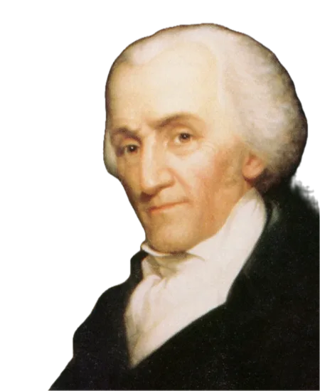
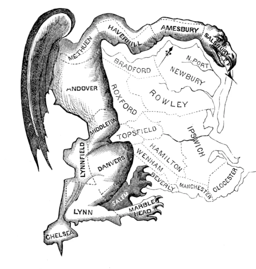
Gerry signs the new map of the state Senate.
The Boston Gazette prints the monster and names it.
The Federalists win more votes, but Gerry's party keeps 29 of the 40 state Senate seats. Gerry himself loses the governorship.
Gerry becomes vice president. The word outlives him.
Gerry said his own name with a hard G, like "Gary". The word kept the soft one.
Portrait: James Bogle (1861). Cartoon: Elkanah Tisdale (1812). Both public domain, via Wikimedia Commons; the portrait is cut out and in black and white.
01 · The voters
Blue has 60% of the votes. The state must be cut into 5 districts of 5 voters, and each district elects one representative: whoever holds 3 of its 5 voters wins.
02 · A plain map
Nobody tried anything here. Blue gets 60% of the seats with 60% of the votes. Now let's draw the map for Red.
03 · Step 1 · Packing
Squeeze as many Blue voters as possible into a few districts. Blue wins those 5–0, but it only needed 3: two of every five votes there change nothing.
04 · Step 2 · Cracking
Spread the remaining Blue voters thinly across districts where Red wins by a little. Blue is a real minority in each one, and loses all three.
05 · The result
Faded dots are wasted votes: votes for the loser, or winning votes beyond the 3 needed. Blue wastes 9, Red only 1. That gap is the fingerprint of a gerrymander.
06 · And the other way
Same voters, a different pen. Every district is 3 Blue to 2 Red, so all 10 Red votes are wasted. Both parties do this wherever they hold the pen.
02 Your turn
Paint five districts of five connected squares. Pick a goal, choose a district colour and drag across the board.
Red has 40% of the votes. Draw a map where Red wins at least 3 of the 5 districts.
Tip: drag to paint. Start a stroke on your own district to erase.
03 How it gets caught
There are exactly 4,006 ways to cut this little state into five connected districts. Researchers do the same with real states, using computers to draw thousands of legal maps and checking whether the enacted one is an outlier.
04 Real shapes
A strange shape is not proof of a gerrymander, and a tidy one is no guarantee of fairness. But extreme shapes are often where the lines were bent hardest. The Polsby-Popper score compares a district with a circle: 1 is a perfect circle, 0 is a thread.
Louisiana's second majority-Black district. The Supreme Court struck it down as a racial gerrymander in Louisiana v. Callais (2026).
Texas redrew both of these again for 2026.
Drawn by Illinois Democrats in 2021.
For contrast: one district, the whole state, no lines to draw.
05 Slicing a city
Cities vote Democratic, the countryside Republican. So the weird shapes usually follow one of three recipes: slice a city into wedges that each reach out into rural land, pack it into one seat, or stitch scattered cities together. Here are real examples, with the House results before and after the lines moved.
Cracking · Republicans, 2022
For decades Nashville elected a Democrat in TN-5. In 2022 the Republican legislature cut Davidson County into three wedges, each running from the city out into rural counties like a slice of pizza. In every slice the city's Democrats are outnumbered by the countryside, so a county that votes Democratic by 27 points now sends three Republicans to Congress.
Davidson County: D+27 for president in 2024
| District | Old map | New map | |
|---|---|---|---|
| TN-05 | D+36 2018 | R+17 2024 | |
| TN-06 | R+50 2020 | R+36 2024 | |
| TN-07 | R+43 2020 | R+22 2024 |
House results by district. Lines shown are the maps used in 2022 and 2024.
The same recipe keeps coming back: Tennessee's 2026 map splits Memphis three ways, and Missouri's 2025 map stretched Kansas City's district out into rural Missouri before a referendum petition put it on hold. Missouri votes on its 2022 lines this year.
06 The 2026 map war
District lines are normally redrawn once every ten years, after the census. Ahead of 2026, Texas started an unusual mid-decade round at the White House's urging, and both parties answered state by state. Missouri redrew too, but a referendum petition has kept its new map from being used this year.
+5
+4
+2
+1
+1
+1
+1
+5
+1
Missouri · Indiana · Virginia · South Carolina
Missouri passed a map in 2025, but a referendum petition froze it until voters decide on November 3, so the state votes on its 2022 lines; Indiana's state Senate voted a new map down; a court blocked Virginia's redistricting referendum; South Carolina's plan died in the legislature.These are ceilings, not forecasts. Spreading your own voters thin creates more winnable seats but fewer safe ones, so a strong year for the other side can flip an aggressive map against its authors. Strategists call that a dummymander. NBC's June estimate also counted one Republican seat from Missouri. That map is out for 2026: in September the Missouri Supreme Court upheld the referendum petition and the U.S. Supreme Court halted an appeals court order reviving the map, and in October the Census Bureau reissued its 2026 district files with Missouri's 2022 lines. Sources: NBC News, Ballotpedia, CRS, PBS NewsHour, Census Bureau.
07 Can it be fixed?
There is no single fix. Each one moves the decision somewhere else.
States such as California, Arizona, Michigan and Colorado hand the map to independent citizen commissions. The catch: a state can take the pen back. California's voters set their commission map aside for 2026–2030 with Proposition 50.
In Rucho v. Common Cause (2019) the U.S. Supreme Court said federal courts cannot police partisan gerrymanders. State courts and state constitutions still can: that is how Utah got a new map in 2025.
Drawing districts by race is unconstitutional unless the Voting Rights Act requires it. In Louisiana v. Callais (April 2026) the Supreme Court narrowed what that law requires, and several Southern states redrew their maps within weeks.
Compactness scores, wasted-vote counts and ensembles of thousands of computer-drawn maps turn "this looks rigged" into evidence a court can weigh.
Every one of these lines is on the ballot on November 3.